20- DAY INMERSION
C
BUENOS AIRES + COUNTRY TOUR:
After 13 days of intensive immersion in Buenos Aires city, milongas, classes, etc, the COUNTRY TOUR offers you a 5 days trips to know the natural beauty of our country + 1 more in Buenos Aires.
We believe that combining the Tango trip with a some days of tourism is THE BEST COMBINATION!!!
10
MILONGAS
M
WHAT YOU'VE BEEN WAITING FOR!:
We go through the best-known milongas, the most popular and the most traditional. We choose according to the shows and the live Orchestras!!!
We divided the circuit of milongas into 3 types:
-
Milongas in C.I.T.A with shows and 2 live orchestras every nigth.
-
Milongas or Prácticas: where you will dance a lot, social and relaxed atmosphere.
-
Milongas that you must know because they are the important milongas of Buenos Aires. With shows or live Orchestras.

M
11
CLASSES
16 HOURS OF CLASSES:
-
7 Workshops with your choice of C.I.T.A.'s top maestros.
-
2 Workshops with Anibal and Valeria.
-
2 Workshops of Argentine Folklore (Zamba and Chacarera) with guest teachers.

S
GASTRONOMIC EXPERIENCES:
We will take you to special places and restaurants, some hidden (great secrets of Bs As) with the best gastronomic quality, not frequented by tourists, far from the center. We do not want to specify their names because we want them to continue to be maintained in this way.
Vegetarian options too!!!!!
Special dinner with an internationally renowned "Tango Dinner Show" with live music, with incredible international cuisine and first-class service.
Additionally, on the country tour, we'll have the opportunity to sample typical local dishes from each region of the country.

SHOPPING TIME

M
THE MEALS
11
We take you shopping at the best in price and quality tango stores (clothing and shoes).
We save you a lot of searching time!!!!
9
EXCURSIONS
E
COUNTRY TOUR: A 6 DAYS TRIP TO KNOWTHE NATURAL BEAUTY OF OUR COUNTRY:
CATAMARCA PROVINCE
Catamarca is located in the northwest of the country, in the Argentine Norte Grande region, bordering Salta to the north, Tucumán and Santiago del Estero to the east, Córdoba to the southeast, La Rioja to the south, and Chile to the west. Its border is determined by the watershed of the Andes mountain range. With 368,000 inhabitants in 2010, it is the fifth least populated province in the country.
The word "Catamarca" is of Quechua origin and means "Castle" or "Fortress on the slopes." Cata means "skirt" or "hillside," and marca means "castle" or "fortress."
It was inhabited by the native population of the region for several millennia until the intervention of the Spanish conquistadors in the mid-17th century. Since then, it has received various groups of immigrants, especially Spaniards, although unlike other Argentine provinces, these have not outnumbered the native population. And the mixture of both groups gave rise to the province's current population, composed primarily of whites and mestizos.
Its economy is one of the most diversified in the country, primarily focused on mining, industry, commerce, tourism, livestock, and agriculture.

TERMAS DE FIAMBALA
Fiambalá Hot Springs is a hot springs complex located 14 km from the town of Fiambalá, Tinogasta Department, Catamarca Province, Argentina.
It has a total of 14 sloping pools into which thermal waters of varying temperatures flow almost naturally. The ecological characteristics of the materials used to build these pools, the mountainous area in which they are located, and the healing properties of their waters make them an attractive tourist destination.

EL BALCON DE PISCIS
The "Balcón de Piscis" is a natural viewpoint at approximately 4,500 meters above sea level in Catamarca, Argentina, overlooking Mount Piscis, located on a branch of the Andes mountain range within the Puna plateau region of Argentina, between the provinces of Catamarca and La Rioja. This volcano is the third-highest peak in the Southern and Western Hemispheres, with an altitude of 6,795 meters above sea level.
The Balcony offers views of other nearby volcanoes and lagoons, such as Laguna Verde and Laguna Celeste. It is a popular tourist destination in the region, accessible from Fiambalá via National Route 60.
From the Balcony, you can see other points of interest such as Walter Penk Volcano, Tres Cruce Volcano, Laguna Celeste, Laguna Negra, and Laguna Verde.
Of volcanic origin, it is a mountain with six peaks. Classified as a composite volcano, the main characteristic of this type is the existence of several summits and superimposed craters. Together with its satellite peaks, it forms the Pissis mountain range or range, oriented from northwest to southeast. The Pissis range, in addition to its main massif, has eight aligned peaks, one of which (Pissis Shoulder) exceeds 6,400 m above sea level, three others exceed 6,000 m above sea level, and the rest exceed 5,500 m above sea level. It constitutes the northern rim of the enormous Inca Pillo crater. It forms part of the circle of giant volcanoes, along with Bonete, Baboso, Reclus, Gemelos, and the Bonete and Pissis ranges. The northern slopes of the massif close the Laguna Verde Salt Flats basin to the south and are the northern limit of the Laguna Inca Pillo basin.

ANTOFAGASTA DE LA SIERRA
Antofagasta de la Sierra is the capital of the department of the same name in the province of Catamarca (Argentina), in the heart of the Andes mountain range, in the Puna region.
Antofagasta de la Sierra, known as "the gateway to heaven," is located at 3,323 meters above sea level, surrounded by mountains that rise to over 6,000 meters and close to enormous salt flats. It is the main oasis of the Catamarca Puna. It is also the highest departmental capital in the province and the farthest from the capital city, San Fernando del Valle de Catamarca.
Its climate is harsh, continental, cold, and dry, with minimum temperatures below 0°C, a daily temperature range exceeding 30°C, and annual rainfall of less than 200 mm. The departmental capital, along with other nearby towns, is located within the geological and cultural region known as Las Parinas, a geographical area characterized by an extremely cold and harsh climate.
The population is composed primarily of descendants of indigenous peoples: Diaguita and Atacameños, although mixed with Creoles. In recent years, the population has grown to 730 inhabitants (Indec, 2010), representing a 9% increase compared to the 667 inhabitants (Indec, 2001) reported in the previous census. The municipality has a population of 1,342. Due to its highly isolated location, the sex ratio is high: 107.

DUNAS DE TANTON
The Tatón Dunes, or Medanitos Dunes, are a desert area near the town of Tatón, Catamarca, characterized by a large number of dunes or sand dunes of considerable size. Located there is the Federico Kirbus Dune, considered the highest in the world at 1,230 meters above sea level, far ahead of the second highest, the also American Duna Grande in Peru.
This area is located in the west of the province of Catamarca, in the department of Tinogasta. It is close to both the town of Tatón and Fiambalá.
The area is characterized, as its name suggests, by the predominance of dunes (also called dunes), which extend between the hills, changing their shapes due to the force of the wind. The landscape was described by geologist Alfred Stelzner as "sand glaciers."
The area is mainly used for sandboarding and 4x4 vehicle tours. It is also one of the Dakar's favorite locations for competitions.

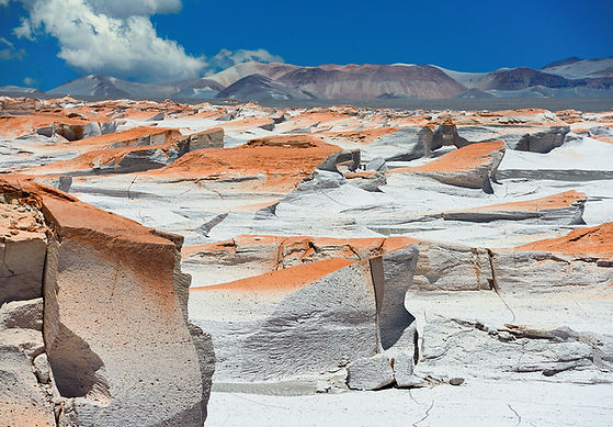
CAMPO DE PIEDRA POMEZ
The Campo de Piedra Pómez Protected Natural Area is a protected natural area located in the Antofagasta de la Sierra department. It is characterized by the extensive accumulation of pumice, which, after millennia of erosion, acquired its current morphology.
Phytogeographically, it belongs to the high Andean and Puna provinces, characterized by arid soils, wide daily temperature ranges, and very low rainfall. The low atmospheric pressure and reduced oxygen dilution in the air create the typical Puna environment.
It covers an area of 75,489 hectares, with elevations ranging from 3,050 to 4,850 meters above sea level.
Its origins show clear evidence of volcanism. The area itself was presumably formed 100,000 years ago as a result of emissions from nearby volcanoes, especially the Blanco or Robledo Volcano, whose crater or caldera can be visited a short distance southwest of the main sedimentation area. According to some scientific research, the formation of the basin could have been due to volcanic events that occurred between 20 million and 10,000 years ago.
LAS YUNGAS
Yungas or Yungas are regions or ecoregions of Andean forest and montane rainforest along the eastern flank of the central Andes. They extend from northern Peru through Bolivia to northern Argentina and are characterized by mountain, cloud, rain, and tropical forests. If the definition is expanded to include the northern Andean forest, the region extends to Colombia and Venezuela.
They are generally considered to range from an altitude of 300 or 600 meters above sea level to 3,000 or 3,800 meters above sea level. In the lower reaches, they are characterized by dense, humid, evergreen forest vegetation that rivals the Amazon rainforest in biodiversity, but in the higher reaches, the forest gives way to deciduous mountain forest, also known as dwarf forest, where shrubs and grasslands predominate.
The climate is generally very rainy, cloudy, and warm, but at higher altitudes or latitudes, temperatures are more extreme, ranging from hot to cold, and rainfall is seasonal, with a dry and a rainy season. The terrain is typically mountainous, with steep to gentle slopes predominating. There are areas of rugged topography, which generally "follow" the channels of rivers and streams, and areas of small micro-valleys surrounded by mountain ranges, often occupied by farmers.
